![](/images/other/stat-length.png)
![Tocht Paardrijden La Tieule - Etoile La Tieule par Rouge Parets - Photo](https://media.geolcdn.com/t/1900/400/ext.pjpeg?maxdim=2&url=https%3A%2F%2Fstatic1.geolcdn.com%2Fsiteimages%2Fupload%2Ffiles%2F1524743154cheval.jpg)
Etoile La Tieule par Rouge Parets
Lozère Cheval
Gebruiker
![Lengte](/images/other/stat-length.png)
Lengte
26 km
![Max. hoogte](https://static1.geolcdn.com/siteimages/upload/files/1508320355ic_sort_altitude_max_24dp.png)
Max. hoogte
956 m
![Positief hoogteverschil](https://static1.geolcdn.com/siteimages/upload/files/1508320355ic_sort_den_pos_24dp.png)
Positief hoogteverschil
728 m
![Km-Effort](/images/other/stat-length.png)
Km-Effort
36 km
![Min. hoogte](https://static1.geolcdn.com/siteimages/upload/files/1508320355ic_sort_altitude_min_24dp.png)
Min. hoogte
770 m
![Negatief hoogteverschil](https://static1.geolcdn.com/siteimages/upload/files/1508320355ic_sort_den_neg_24dp.png)
Negatief hoogteverschil
738 m
![Boucle](https://static1.geolcdn.com/siteimages/upload/files/16400158638029165_repeat_loop_refresh_sync_direction_icon.png)
Boucle
Ja
Datum van aanmaak :
2021-01-15 15:23:09.161
Laatste wijziging :
2021-01-15 15:23:59.451
![Paardrijden](https://static1.geolcdn.com/sitytour/trail-icons/301.png)
4h45
Moeilijkheid : Moeilijk
![Scan deze QR-code om de tocht te openen in de SityTrail-applicatie](https://capi.geolives.com/qq0zvz2zws4bq2lad0pu/sitytour/trails/2641309/qr.png?size=200)
Gratisgps-wandelapplicatie
Over ons
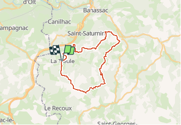
Tocht Paardrijden van 26 km beschikbaar op Occitanië, Lozère, La Tieule. Deze tocht wordt voorgesteld door Lozère Cheval.
Beschrijving
La Tieule en passant par Mas de Donat, Rouget Parets, Gauzines, Maynard, Betones, Esquino d'Aze Retour La Tieule
Plaatsbepaling
Land:
France
Regio :
Occitanië
Departement/Provincie :
Lozère
Gemeente :
La Tieule
Locatie:
Unknown
Vertrek:(Dec)
Vertrek:(UTM)
512443 ; 4914570 (31T) N.
Opmerkingen
Wandeltochten in de omgeving
![Tocht Stappen La Canourgue - Dessus la canourgue - Photo](https://media.geolcdn.com/t/375/260/30a5f5a0-e728-45ed-9aed-a3cadcaf9c1d.jpg&format=jpg&maxdim=2)
![Stappen Stappen](https://static1.geolcdn.com/sitytour/trail-icons/101.png)
Dessus la canourgue
Stappen
Moeilijk
La Canourgue,
Occitanië,
Lozère,
France
![](/images/other/stat-length.png)
9,1 km | 14,4 km-effort
3h 48min
![](https://static1.geolcdn.com/siteimages/upload/files/16400158638029165_repeat_loop_refresh_sync_direction_icon.png)
Neen
![Tocht Stappen Saint-Saturnin - Vers l'antenne de La Canourgue - Photo](https://media.geolcdn.com/t/375/260/04a5ad93-a1c4-4dbe-97ad-0dc573f357dc.jpg&format=jpg&maxdim=2)
![Stappen Stappen](https://static1.geolcdn.com/sitytour/trail-icons/101.png)
Vers l'antenne de La Canourgue
Stappen
Gemakkelijk
Saint-Saturnin,
Occitanië,
Lozère,
France
![](/images/other/stat-length.png)
6,9 km | 8,8 km-effort
1h 42min
![](https://static1.geolcdn.com/siteimages/upload/files/16400158638029165_repeat_loop_refresh_sync_direction_icon.png)
Ja
![Tocht sport La Canourgue - Ta dimanche - Photo](https://media.geolcdn.com/t/375/260/ext.jpg?maxdim=2&url=https%3A%2F%2Fsecurestorage.geolives.com%2Fsitytour%2Ftrail-bg%2Fdefault.jpg)
Ta dimanche
sport
Heel gemakkelijk
La Canourgue,
Occitanië,
Lozère,
France
![](/images/other/stat-length.png)
108 km | 142 km-effort
Onbekend
![](https://static1.geolcdn.com/siteimages/upload/files/16400158638029165_repeat_loop_refresh_sync_direction_icon.png)
Neen
![Tocht Paardrijden La Tieule - La Tieule - Etoile par Le Maynard - Photo](https://media.geolcdn.com/t/375/260/ext.jpg?maxdim=2&url=https%3A%2F%2Fstatic1.geolcdn.com%2Fsiteimages%2Fupload%2Ffiles%2F1524743154cheval.jpg)
![Paardrijden Paardrijden](https://static1.geolcdn.com/sitytour/trail-icons/301.png)
La Tieule - Etoile par Le Maynard
Paardrijden
Moeilijk
La Tieule,
Occitanië,
Lozère,
France
![](/images/other/stat-length.png)
27 km | 37 km-effort
4h 53min
![](https://static1.geolcdn.com/siteimages/upload/files/16400158638029165_repeat_loop_refresh_sync_direction_icon.png)
Ja
![Tocht Paardrijden La Tieule - Etoile de Coustaraços ( La Tieule par Meynard et Pertuzades) - Photo](https://media.geolcdn.com/t/375/260/ext.jpg?maxdim=2&url=https%3A%2F%2Fstatic1.geolcdn.com%2Fsiteimages%2Fupload%2Ffiles%2F1524743154cheval.jpg)
![Paardrijden Paardrijden](https://static1.geolcdn.com/sitytour/trail-icons/301.png)
Etoile de Coustaraços ( La Tieule par Meynard et Pertuzades)
Paardrijden
Zeer moeilijk
La Tieule,
Occitanië,
Lozère,
France
![](/images/other/stat-length.png)
29 km | 42 km-effort
5h 33min
![](https://static1.geolcdn.com/siteimages/upload/files/16400158638029165_repeat_loop_refresh_sync_direction_icon.png)
Ja
![Tocht Stappen La Tieule - Chemin de St Guilhem - La Tieule - Saint Georges de Lévéjac - Photo](https://media.geolcdn.com/t/375/260/ext.jpg?maxdim=2&url=https%3A%2F%2Fstatic1.geolcdn.com%2Fsiteimages%2Fupload%2Ffiles%2F1553511878bg_sport_marche.png)
![Stappen Stappen](https://static1.geolcdn.com/sitytour/trail-icons/101.png)
Chemin de St Guilhem - La Tieule - Saint Georges de Lévéjac
Stappen
Zeer moeilijk
La Tieule,
Occitanië,
Lozère,
France
![](/images/other/stat-length.png)
21 km | 28 km-effort
5h 56min
![](https://static1.geolcdn.com/siteimages/upload/files/16400158638029165_repeat_loop_refresh_sync_direction_icon.png)
Neen
![Tocht Paardrijden La Tieule - Grande Boucle Tieule/Canourgue/Champerboux/StEnimie/MasRouch/Tieule - Photo](https://media.geolcdn.com/t/375/260/ext.jpg?maxdim=2&url=https%3A%2F%2Fstatic1.geolcdn.com%2Fsiteimages%2Fupload%2Ffiles%2F1524743154cheval.jpg)
![Paardrijden Paardrijden](https://static1.geolcdn.com/sitytour/trail-icons/301.png)
Grande Boucle Tieule/Canourgue/Champerboux/StEnimie/MasRouch/Tieule
Paardrijden
Zeer moeilijk
La Tieule,
Occitanië,
Lozère,
France
![](/images/other/stat-length.png)
91 km | 123 km-effort
15h 4min
![](https://static1.geolcdn.com/siteimages/upload/files/16400158638029165_repeat_loop_refresh_sync_direction_icon.png)
Ja
![Tocht Paardrijden La Tieule - Boucle La Canourgue/ La Tieule / Mas Rouch - Photo](https://media.geolcdn.com/t/375/260/ext.jpg?maxdim=2&url=https%3A%2F%2Fstatic1.geolcdn.com%2Fsiteimages%2Fupload%2Ffiles%2F1524743154cheval.jpg)
![Paardrijden Paardrijden](https://static1.geolcdn.com/sitytour/trail-icons/301.png)
Boucle La Canourgue/ La Tieule / Mas Rouch
Paardrijden
Heel gemakkelijk
La Tieule,
Occitanië,
Lozère,
France
![](/images/other/stat-length.png)
66 km | 91 km-effort
Onbekend
![](https://static1.geolcdn.com/siteimages/upload/files/16400158638029165_repeat_loop_refresh_sync_direction_icon.png)
Ja
![Tocht Stappen Campagnac - Campagnac - Photo](https://media.geolcdn.com/t/375/260/ext.jpg?maxdim=2&url=https%3A%2F%2Fstatic1.geolcdn.com%2Fsiteimages%2Fupload%2Ffiles%2F1553511878bg_sport_marche.png)
![Stappen Stappen](https://static1.geolcdn.com/sitytour/trail-icons/101.png)
Campagnac
Stappen
Heel gemakkelijk
Campagnac,
Occitanië,
Aveyron,
France
![](/images/other/stat-length.png)
14 km | 17,9 km-effort
5h 52min
![](https://static1.geolcdn.com/siteimages/upload/files/16400158638029165_repeat_loop_refresh_sync_direction_icon.png)
Ja